
TRACKING DOWN ANCIENT HIGHWAYS
DELAMERE FOREST, PEYTEFYNSTY & A ROMAN ROAD
(by R.M.Bevan)
AUTHOR'S INTRODUCTION: The whereabouts of the ancient public highway of Peytefynsty has long challenged Cheshire historians as it is thought to have been the boundary between the old forests of Mara and Mondrem which, together, stretched from Frodsham almost to the borders of Nantwich, the remnants of which remain as Delamere Forest.
In 1939, following an earlier article in 1922, Ronald Stewart Brown, a noted historian and contributor to the Cheshire Sheaf, identified Peytefynsty as having been on the line of the modern A49, from Weaverham, via Cuddington, to Tarporley, and this has since been accepted as the definitive route.
Whilst studying over many years the history of the village of Cuddington & Sandiway, my birthplace, I have been intrigued with references to Peytefynsty and, particularly, its connection with the boundary stones of the former Cistercian abbey of Vale Royal. Several recent, serendipitous discoveries, combined with parochial knowledge and a widening of research into neighbouring topography, have yielded new information which calls into question Stewart Brown's findings.
This paper presents an alternative conclusion and, later, considers the boundary stones in relation to a Roman road that is believed to have crossed from the eastern edge of Delamere Forest to Weaverham and Saltersford, a subject in which I became deeply interested through my good friend the late David Coxhead.
PEYTEFYNSTY
In 1939 Ronald Stewart Brown published (Footnote 1) research to show the definitive route of the ancient highway of Peytefynsty (F2). His findings were essentially based upon an interpretation of two records contained within the Vale Royal Abbey Ledger Book (F3), dated 1275 and 1359. He also cross-referenced to Enclosure plans and 17th century documents relating to the boundaries of Delamere Forest. However, with one exception, he was unable to identify the locations of the stone markers referred to in the Vale Royal records. These records provide the only contemporary description of Peytefynsty since it formed the north-western boundary of the abbey lands.
Vale Royal Abbey was founded during the 13th century by King Edward I and survived as a powerful local presence until the Dissolution of the Monasteries in the 16th century. To create what he pledged would the greatest abbey in his kingdom, Edward I carved lands from the Forest and one of the principal settlements allotted to the Abbey was Weaverham.
A small part of Weaverham included Sandiway (Sandyway or Sandiakos).
Sandiway is now joined with Cuddington to form the sprawling village of Cuddington & Sandiway. It was not always so. Cuddington and Sandiway were once separate administrative entities, divided by a boundary. On one side of this boundary, i.e. “Outside the Forest”, was Sandiway, a lordship of Weaverham within the bounds of Vale Royal Abbey. On the other side, principally to the west, i.e. Within the Forest, was Cuddington, an independent township. Cuddington did not merge with Sandiway until 1935. Most of the post-war housing estates in present Cuddington & Sandiway have been developed on what was once Bryn Common, also known as the Commons of Cuddington. The council housing estate was the first of these to be built,1949/50, and two of the roads were allotted the names Boundary Lane North and Boundary Lane South, moreorless marking the centuries-old boundary that had distinguished Cuddington from Sandiway.
New Evidence
The key to discover the correct route of Peytefynsty lies in identifying five marker stones. Three are mentioned in the 1275 and 1359 Vale Royal Abbey records, a fourth in the Cuddington Enclosure Award of 1767, a fifth in Stewart Browns account, garnered from Delamere Forest records to which he had access. It is noteworthy that the 1275 Abbey record pre-dates, by two years, the laying of the foundation stone of Vale Royal Abbey by Edward I. In 1275 the Abbot and monks were either still at Darnhall (the original site), or they were in makeshift accommodation at the new site.
The 1275 record relating to the boundaries states:
...within these bounds, from Weaverham to Olrinschawe, thence crossing to le Sandiakos, thence to the metes (boundaries) of Cuddington; on the other part from Sandiakos to Harebachcross, ascending the conduit to Croukinsdale, thence to Peytevinnisty and along the road to Welminglowe, thence leaving the wood on the left to Legemerefords, thence to Hullhul and Stonemarcokis, and following le egge to the metes of Norley and Cuddington.
The 1359 record states:
John de Wnygfeld, knight, and the aforementioned John de Burnham, chamberlain of Chester, had therefore set forth and ridden out by command of the said Prince; which begin, to wit, from a place where Peytefinsty descends to the commons of Cudynton, to the stone put and ordained there, and from there to a certain heap of stones towards the south on the high way which leads from Chester to Northwich, between Little Blakemere and Harebachcross. and from there straight towards the belfry of Acton...
So where were the markers and locations mentioned in the two records? Some are easily identifiable, others are more tantalising. Blakemere/Little Blakemere is an easy one and was indentified by Stewart Brown. Blakemere was once a large pool of water, the Black Mere, in the apex of the modern A556 and A49, opposite to the Shell service station. A stream from the Black Mere flowed towards the Lobslack valley and Ravensclough, west of the A49.
This stream, near to Harebachcross, seems to have been the conduit mentioned in the 1275 record. Croukinsdale was perhaps an early name for Blakemere. Welminglowe and Legemerefords are lost names, though it matters little within the context of locating the route of Peytefynsty. It may be mentioned here that Stewart Brown incorrectly placed “Sandiway crossroads” at the A49 – A556 (Shell service station) crossroads. The A49-A556 crossroads has never been in Sandiway, although the present-day, modified parish boundary of Cuddington & Sandiway runs through here on the line of the A49.
1 Stonemarcokis:
According to the 1275 description, Stonemarcokis was near to the metes of Norley and Cuddington, i.e. the place where the boundaries meet. The ancient boundaries of Norley and Cuddington still meet in Stonyford Lane, west of Crabtree Green crossroads. It is therefore highly probable that Stonemarcokis was located in what is now called Stonyford Lane (Grid ref: 581701). The name Stonyford may derive from Stonemarcokis and not from the stoney ford which is the accepted derivation. With Stonemarcokis located in Stonyford Lane it is possible that Hulhul (VR 1275 record) was an early name for Crabtree Green.
2 Harebachcross:
The name Harebachcross occurs in both the 1275 and 1359 records. Stewart Brown also found reference to it in the 17th century description of the Delamere Forest boundaries, although slightly corrupted to Erbach Cross. Teesdales Map of 1829/30 marks it as Abbots Cross, close to the present day junction of the A49 Forest Road and Ash Road (Grid Ref 598708). The Dictionary of English Placenames (F4) indicates that Hare may refer to a boundary or pile of stones, whilst Bach suggests a brook. Placed together we have boundary-brook-cross which is entirely consistent with a location alongside the conduit mentioned in the 1275 Vale Royal record. In short, Harebachcross was a boundary stone marker alongside a brook.
The site of Harebachcross remains on the parish boundary of modern Cuddington & Sandiway. Until recently this boundary followed the dried-up course of the conduit from Blakemere (Croukinsdale) to Harebachcross.
3
a place where Peytevynsty descends to the commons of Cudynton, to the stone put and ordained there:
This is identified with certainty as the Toolerstone, at Ashbank, Sandiway (Grid Ref 608715). It is the only possible location for the Abbot to place and ordain an important marker stone, i.e. a corner of the boundary, where the Weaverham/Sandiway abbey lands met with the Commons of Cuddington/Forest.
The Toolerstone stands approximately thirty yards from Weaverham Road, along the south side of an old green lane known as Hunts Lane. The Toolerstone was unearthed during the 1930s and those (F5) responsible for its re-erection placed it exactly at the location, according to the Weaverham Tithe Map (F6), i.e. where the boundaries of Weaverham and old Sandiway dog-legged to meet with the Commons of Cuddington.
4
Sandiway Cross:
The Cuddington Enclosure Map (F7) of 1767 includes a reference to what is now Norley Road, passing east from the White Barn to Northwich by Sandiway Cross. There seems little doubt that Sandiway Cross refers to the crossroads of Weaverham Road and Norley Road which, in 1767, was just inside the Weaverham/Sandiway boundary (Grid ref: 605713). It is unlikely that the term Sandiway Cross was shorthand for Sandiway Crossroads and, significantly, the later Weaverham Tithe Map (1838) shows a sizeable open area here, suggestive of a site more important than a mere intersection of two roads. One has to conclude that Sandiway Cross was, at the very least, an old name, a throwback to a wayside cross. It may be a coincidence but the religous connotation resonates here with the founders of Primitive Methodism who built one of the very earliest chapels on this crossroads, Bryn Chapel, in 1819.
5 Old cross at Astmore Knowle:
Stewart Brown was unable to identify the location of Astmore Knowl upon which, according to the 17th century Forest documents, there stood an old cross. He states it was near to Padfield Way which he felt sure was a corruption of Peytefynsty. By chance, during unconnected reseach associated with Oakmere Hall, the location of “Astmore Knowle Cross” is now identified.
Within the 1868 combined sales particulars of the Oakmere Hall and Sandiway Lodge estates (F8) there is a reference to Ashmeer Knowl Wood which is marked as Lot 19 on one of the accompanying plans. This wood was on the east side of Kennel Lane, at Sandiway, near to the Cheshire Hunt Kennels. For Ashmeer Knowl Wood we can surely read Astmore Knowle Wood.
Knowl/knoll refers to a small hillock, or mound, and across the lane from the wood, in the open fields, there is a noticeable mound, almost certainly Astmore Knowle (Grid ref: 598697). It is a few hundred yards south of the Cheshire Kennels on the west side of Kennel Lane, just beyond where the lane becomes a sandy trackway. The modern parish boundary of Cuddington & Sandiway runs near to this point.
The Route of Peytefynsty
The identified locations of stone markers reveal that, north to south, Peytefynsty followed the line of present-day Gorstage Lane and Weaverham Road, Ashbank/Toolerstone and Sandiway Cross to Astmore Knowle. Figure 10 shows the route beyond Astmore Knowle, via the Longstone (Grid ref: 589677), Little Budworth Church, Eaton Cross and Cobblers Cross to Tarporley Church. The Longstone and Eaton Cross are, at least, medieval in origin, whilst churches at Little Budworth and Tarporley are recorded from the 12th and 13th centuries. Bryants and Burdetts maps, as well as modern OS maps, show the remnants of Peytefynsty in the form of interlocking green lanes (F9) and public footpaths. The possibility must also be considered that, beyond Tarporley, Peytefynsty was an early route from the Iron Age hill fort at Beeston crag to the crossings of the River Weaver to the north.
As stated earlier, Stewart Brown interpretated from the Forest records that the name Peytefynsty had been corrupted to Padfield Way. This is incorrect. Apart from one section, Peytefynsty and Padfield Way were entirely different. What probably occurred between the 13th century Vale Royal records and the 17th century Forest records was a redefining of the line of Peytefynsty, brought about by the old trackway impinging upon the estates of major landowners. One was at Oulton, the Cheshire seat of the Egertons from the 16th century. The other, and the one that perhaps had the most profound effect upon the route of Peytefynsty, was at Abbots Moss. This area was once part of the Vale Royal Abbey lands later acquired by the Cholmondeley family. Here stands Abbots Moss Hall (Grid ref: 594683), Georgian though likely built on the site of a much earlier house, possibly dating from the Cholmondeleys acquisition of the Vale Royal lands early in the 17th century. Peytefynsty passed close to the site of Abbots Moss Hall and it hardly takes a leap of imagination to appreciate that a diversion, a simple re-routing, became necessary onto the nearby Roman road/A49.
It is also reasonable to hypothesise that the Roman road/A49 became the main through route whilst Peytefynsty, although probably earlier, was of lesser importance by this period, a local foot track, a Forest track, the most direct route from Weaverham to Tarporley. Later, combined with the Abbots Moss diversion and turnpiking, Peytefynsty was superseded almost entirely by the Roman road/A49 line.
Padfield Way. Stewart Brown noted: A description of the boundaries of Delamere forest in 1699 (from a MS. book of Sir John Crewe of Utkinton, kindly communicated to me by Mrs W.J.Varley) shows... they ran from Ravensclough (near Cuddington) to Erbach cross, then to Little Blakemere, thence to an old cross on Astmore Knowle, thence to a stone leading into Padfield Way,, by other stones near Masseys Lodge and so along Padfield Way to Sandyford (near Cotebrook).
This suggests one section of Peytefynsty remained part of Padfield Way, i.e. from Weaverham to Kennel Lane and then south west of Astmore Knowle to join the Roman road between the present Masseys Lodge and the Nunsmere Hall Hotel (Grid ref: 593688).
Conclusions
1. The principal marker stones referred to in the Vale Royal Abbey records of 1275 and 1359 have been located and identify the route of Peytefynsty.
2. The 1359 Vale Royal record and the location of the Toolerstone,the place where Peytefynsty descends to the commons of Cuddington show that Peytefynsty passed through Sandiway, but not Cuddington.
3. Peytefynsty cannot have followed the line of the Roman road (A49) as defined by R. Stewart Brown. Pre-1935 the Roman road (A49) passed through Cuddington but did not touch upon Sandiway.
4. Peytefynsty ran south from Weaverham via the Toolerstone, Sandiway Cross and Astmore Knowle, then by other ancient
markers at Little Budworth and Eaton, to Tarporley.
5. The important discovery of the location of Astmore Knowle Cross, as referred to in Delamere Forest records, confirms that by the 17th century Padfield Way had largely replaced Peytefynsty.
6. Padfield Way and Peytefynsty were different routes. For its greater part (Tarporley to Nunsmere Hall) Padfield Way followed the course of the Roman road, now the A49.
7. The creation of the Abbots Moss estate appears to have contributed to the abandonment of Peytefynsty as a recognised public highway.
8. The Vale Royal Abbey boundary that defined Sandiway/Weaverham from Cuddington/Forest remained for almost 750 years until
Cuddington was merged with Sandiway in 1935.
9. The modern parish boundaries of Cuddington & Sandiway touch upon, or are close to, Toolerstone, Harebachcross and Stonemarcokis, markers mentioned in the 1275 and 1359 records of Vale Royal Abbey.
A ROMAN ROAD
Having reviewed the evidence relating to Peytefynsty the following discussion is of merit concerning the direction and purpose of a Roman road which passed from Crabtree Green, on the eastern edge of Delamere Forest, to the Saltersford crossing of the River Weaver, at Weaverham. This road, previously uncharted, was identified in the 1880s by Edward Kirk (F10) whilst plotting the course of the Romans Watling Street from Deva (Chester) to Condate (Northwich) and Manchester (Mamucium). Kirk noted:
I have now to introduce to your notice another hitherto unrecorded Roman road. In the second field west of Crabtree Green Lane there is a junction of two Roman roads, the right-hand road to Northwich and running E.S.E. The left-hand or new road runs E. At the point where these two roads cross Crabtree Green Lane they are some eighty paces apart, the left-hand road here being more strongly marked of the two.
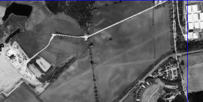
From Crabtree Green Kirk traced the road east, across the Lobslack valley and the cutting of the former Winsford and Over branch railway (now the Whitegate Way).
The two fossae in the wood E of the railway are very distinct, one of them being for some distance through the breast of the bank the depth of a full-sized man. The road, less distinct, continues by the verge of a steep bank on the left now pointing E.N.E.
Beyond the Lobslack valley Kirk suggests the road continued to the present A49, south of Cuddington Station and then, via Handford Brook (Gorstage), to the mound upon which Weaverham church now stands.
We have beyond doubt a Roman road for a considerable distance east of Crabtree Green etc. We have no grounds for supposing that the road terminated at Cuddington.
.
From Google Earth reveals two perfectly straight tracks merging at Crabtree Green. Neither can be seen at ground level. The track marks are on the line of the Roman road from Chester identified by Kirk. The higher track, heading straight ahead, seems to be the older main line. The lower track, the spur, joins the A556.
In 1985 the Lancashire and Cheshire Antiquarian Society published a follow-up paper (F11) in which A.C.Waddelove and E.Waddelove reviewed Kirks work of a century earlier. The Waddleoves concurred with Kirk that a Roman road had run east from Crabtree Green, almost certainly to Saltersford. The Waddeloves state that the remains of a Roman road were found, in 1876, beneath the chancel of Weaverham church. However in regard to the onward direction of the Crabtree Green road from the Lobslack valley they add a note of caution as neither they, nor Kirk, had been able to find clear traces.
Whilst the evidence for its entire exact line is not yet conclusive, there would seem, nevertheless, to be sufficient for accepting that there was indeed a Roman road, running between Crabtree Green and Weaverham.
In order to consider Kirks line it is helpful to look at the early Roman occupation of Cheshire. The Romans established their forward base at Chester around AD 80 (F12). At this time there were Iron Age forts at Kelsborrow (Kelsall), Oakmere and Eddisbury. There were others, of course, along the central ridge and well-used tracks already existed. From Chester and Kelsall one of these well-used pre-Roman tracks would have passed immediately below the Eddisbury hill fort and continued eastwards towards Crabtree Green. It is reasonable to suppose this track provided access from the west to the salt springs and fordable point of the River Weaver, at Northwich, and also the ford below Weaverham (Saltersford).
The Roman II Legion moved up to the Dee from Wroxeter. One of its initial tasks was to quell opposition in Wales; the other was to advance on the Brigantes in Lancashire. The difficulty surely encountered by commanders at Chester in those early times of occupation was how to make their expedient move north. Frodsham Marshes would have presented an initial, impenetrable barrier and the practicable alternative, the quickest way north, can only have been via an existing trackway to the established crossings of the River Weaver, at Northwich and Saltersford.
If the principal track to the Weaver fords was hastily improved to allow passage of the military it explains why the easterly road from Crabtree Green appeared to Kirk and the Waddeloves to pre-date the Chester-Manchester road. However, their reasoning seems flawed that the Crabtree Green road had a single purpose, i.e. towards Weaverham and Saltersford. As no other roads have been found, one may conjecture that the early Crabtree Green road accessed Northwich as well as Weaverham and Saltersford, a dual purpose.
A further issue in dispute is Kirks belief that the Crabtree Green road continued from the Lobslack valley towards Cuddington Station and Handford Brook. For its greater part this route would have crossed low-lying terrain, susceptible to local flooding even today.
There is an alternative and it stands out. From the Lobslack valley, at the point where Kirk angles the road towards Cuddington Station, there is an obvious straight line to the high ground (Grid Ref 598708) in the fields to the west of the modern A49 Forest Road/Ash Road junction at Cuddington. From here, a continuation east would partly have followed the ridge of the 70ft contour to pass down to Ashbank, at Sandiway (Grid Ref 608715). Below Ashbank, only for a relatively short distance in the Gorstage valley, would the road have crossed low-lying terrain on its course towards the Weaverham mound.
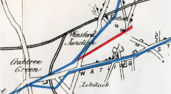
Extract from plan traced by Edward Kirk. The lower blue line is the A556
Chester to Manchester road. The higher blue line is Kirks Roman road from Crabtree
Green towards Weaverham. From the Lobslack valley he angled this road E.N.E
towards Cuddington Station. The red line is added to Kirks plan
to show a continuation due east to Ashbank, Sandiway.
The three points (Crabtree Green, A49 Forest Road, Ashbank) are in alignment and would have been visible, one to the other.
Of the three locations the most intriguing is Ashbank as from here there would have been not only direct access but also uninterrupted views to:
(i) the Weaverham mound and Saltersford.
(ii) the salt springs and the ford at Northwich.
There is a B-road from Ashbank to Weaverham, but it is a winding lane, its course altered by the building of the railway. More consistent with a continuation of a Roman road is a line passing from Ashbank to near to where Gorstage Green Farm (Grid ref: 613727) is located, in the Gorstage valley.
Additionally, from Ashbank, there is the green lane, Hunts Lane, running directly towards Northwich. A gate, erected thirty or forty years ago, stands across the entrance and, at first glance, rather gives a false impression. Previously Hunt’s Lane was ungated and open onto Weaverham Road (F13)
So could Ashbank have been of initial, strategic importance to the Romans, not only for plotting the way ahead to the two fords, but perhaps as a defensive vantage point to maintain a wary eye for any inward invasion from the Brigantes of Lancashire?
It is impossible to be dogmatic but Ashbank is not easily dismissed within the context of the earliest Roman occupation of Cheshire. It is also curious that the three points of the Roman road re-appear almost one thousand years later in the records of Vale Royal Abbey: Stonemarcokis (Crabtree Green) Harebachcross (A49/Forest Road), Toolerstone (Ashbank).
Members of the Weaverham History Society have long been searching for traces of the Roman road through Weaverham, based upon Kirks projected line. The Ashbank point of reference indicates a different line, passing near to Gorstage Green Farm to the Weaverham church mound.
Footnotes:
1. R.Stewart Brown, Cheshire Sheaf, Vol XIX (1922), No 4546/Vol XXXIV (1939), No 7538.
2. An Old English/Anglo Saxon interpretation of the name Peytefynsty could beroad/path
through a fen/peat bogs/mosses. It is noteworthy that the terrain between Little Budworth,
Abbots Moss and Astmore Knowle fits this description.
3. The Ledger Book or Green Book of the Cistercian abbey of Vale Royal, edited by John Brownbill,
British History Online, Monastic and Cathedral Records.
4. The Dictionary of English Placenames, A.D.Mills, Oxford University Press.
5. Colonel J.A.Saner, retired engineer to the Weaver Navigation Trustees and responsible for the
electrification of the Anderton Boat Lift, lived at Toolerstone house, Sandiway. He enlisted
the help of local boy scouts to erect the stone where it now stands.
6. Weaverham Tithe Map (1838), Tithe Maps Online, Cheshire Archives and Local Studies.
7. Cuddington with Bryn Enclosure Award, Cheshire Archives and Local Studies, QDE 1/1
8. Sale plans of Oakmere Hall and Sandiway Lodge estates, 1868, Cheshire Archives and
Local Studies DLI/21/1.
9. A green lane is a physical description of an unsurfaced track, often, but not always, of some antiquity,
normally bounded by hedges, walls, fences or ditches.
10. Roman Roads in Delamere Forest and neighbourhood, Edward Kirk, Lancashire and Cheshire
Antiquarian Society, Vol III, 1885.
11. Roman Roads in Delamere Forest and Neighbourhood A Century after Edward Kirk,
A.C.Waddelove and E.Waddelove, Lancashire and Cheshire Antiquarian Society, Vol 83, 1985.
12. Romans in Cheshire, Tom Garlick, Dalesman Publishing Co Ltd, 1973.
The Roman Army, An Illustrated Study, Graham Webster, Grosvenor Museum, Chester, 1956.
13. Raymond Lloyd (2012), who farmed at Ashbank Farm for almost sixty years, erected the gate.
Unsolicited Mr Lloyd, now in his nineties, said he had been told as a young man that Hunts Lane was
part of an old Roman road to Northwich.